A Spatial Database is a database that is optimized to store and query data related to objects in space, including Point, LineString and Polygon items.
Advances in relational database management technology now gives users the option of storing their GIS data in a spatial database rather than using file based storage. SIS is compatible with the following industry-standard spatial databases:
The following table shows the benefits of using a database as opposed to file based data storage for spatial data:
| File based Storage | Database | |
| File size | usually limited to 2Gb | Unlimited |
| Client Memory Usage | Memory intensive | Memory efficient |
| Multi-user Access | Only crude control, if any | Multi-user access is supported |
| Managing data | Difficult to manage, data may become duplicated |
Central storage of data, easy to locate and backup |
| Security | File system security | Built in security access to data is provided |
| Spatial Analysis and Attribute Searches |
Carried out on the client. Therefore limited to client capability. |
Carried out on the Server. Servers are more powerful, therefore analysis is faster. |
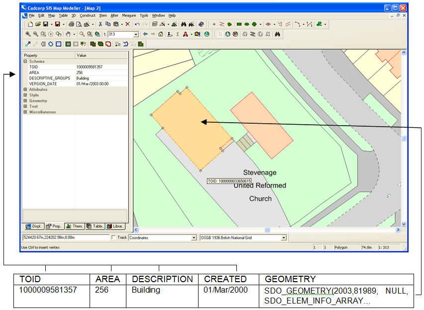
Spatial data is stored in database tables, each spatial feature corresponds to a row in the table. The spatial feature itself is stored in a special geometry type that is available in all three databases. The attribution data associated with each spatial feature is stored in the same table row, each attribute corresponds to a column in the table.
The following figure shows the relationship between a spatial feature displayed in SIS and how it is stored as a row in the database table.

SIS loads most file based data as memory datasets. This means that the entire file is read into memory before the data can be displayed on screen. Once loaded in memory, performance and navigation will be very fast. Load times are dependent on the size of the file and memory available in the machine. File sizes exceeding 50MB will inhibit performance; however this is subject to the amount of memory available for SIS to use. Examples of memory datasets include SIS BDS files, MapInfo .mif files and ESRI .E00 files.
Certain datasets are supplied as files which geographically conform to a known grid. For example Landline is based on the national grid. SIS can read these types of files as index datasets. Because the files are based on a known grid SIS can automatically open and close these files according to the geographical area visible in the map window. This allows SIS to use memory efficiently. Examples of index datasets are OSGB products supplied in a tiled format such as OS Strategi and 1:50,000 raster.
See Loading Data - Cursor Datasets
Cursor datasets generally reside in databases. Data is selected from the database according to the geographical area on display in the SIS Map Window. A spatial index is used to work out the data required by SIS. Examples of cursor datasets are .fdb files, .shp files (with a .prj file) and TAB files.
When creating an overlay using an RDBMS Cursor Dataset users can choose which type of connection to make to the database. Overlays can have one of three modes:
The mode can only be set at the time the overlay is created. Each mode gives the overlay different capabilities:
This mode reads the data into SIS with the following characteristics:
This mode reads the data into SIS with the following characteristics:
This mode reads the data into SIS with the following characteristics:
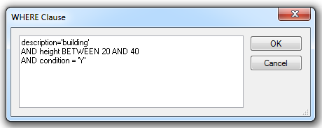
Note: To interrupt the creation of either a Cached Mode or One Off Import Mode data retrieval process press Ctrl+Alt+Break. This is particularly useful when users attempt to create a one off import or a cached mode overlay from a spatial database and forget to specify a Spatial Filter Intersect with current extent in the Spatial Object-Relational WHERE Clause dialog (Oracle dialog shown as an example).

Send comments on this topic.
Click to return to www.cadcorp.com
© Copyright 2000-2017 Computer Aided Development Corporation Limited (Cadcorp).