Add Layers
Select Add Layers from the drop down menu to add layers to the current map.
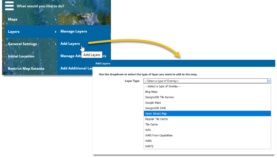
| Layer Type | Description |
|---|---|
|
Allows Bing Maps to be added and used for base mapping, including; Aerial, AerialWithLabels and Road. |
|
|
This adds a Cadcorp tile cache to the map. |
|
|
Allows Google Maps to be used as base mapping. Supported maps include; Terrain, Roadmap, Hybrid and Satellite. |
|
|
Adds all the layers from an SWD stored on the same machine as GeognoSIS, through Microsoft HTTP API. |
|
|
Allows open source OSM data to be added as base mapping (includes OSM Standard Style, OpenCycleMap, OpenCycleMap Transport, MapQuest and MapQuest Open Aerial). |
|
|
Also known as a XYZ Tile Cache or Google Disk. |
|
|
Also known as Disk Tile Cache. |
|
|
Adds data served as an OGC Web Map Feature Service. WFS returns data as actual features with geometry and attributes. |
|
|
Adds all layers from an OGC Web Map Service. The multiple layers can be added as individual overlays, or as a single overlay. WMS simply returns an image of the data. |
|
|
Layers from an OGC Web Map Service can be added to the WebMap site as one overlay. WMS simply returns an image of the data. |
|
|
Adds an OGC Web Map Tile service, which is a standard protocol for serving pre-rendered geo-referenced map tiles over the internet. |
|
|
Adds an OS DataHub WMTS directly to WebMap Admin. |
Note: The maximum number of layers that Cadcorp SIS WebMap can handle is limited to 200.