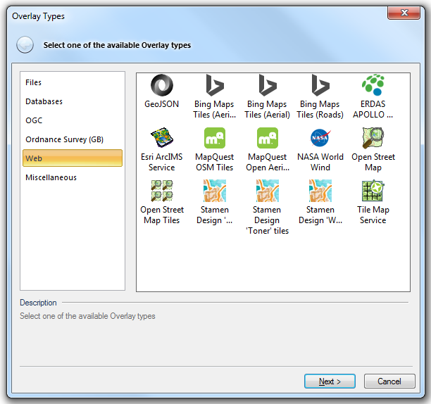

Opens a GeoJSON document.
The document can either be a local (LAN) file or accessed via an HTTP URL.
Click here for the full description of the GeoJSON overlay type.
![]() Bing Maps Tiles (Aerial with labels)
Bing Maps Tiles (Aerial with labels)
Connects to the Microsoft Bing Maps "tile server", and mosaics the tiles together as a seamless image.
A Microsoft Bing Maps "Application Key" is required to use this dataset.
Click here for the full description of the Bing Maps Tiles (Aerial with labels) option.
Connects to the Microsoft Bing Maps "tile server", and mosaics the tiles together as a seamless image.
A Microsoft Bing Maps "Application Key" is required to use this dataset.
Click here for the full description of the Bing Maps Tiles (Aerial) option.
Connects to the Microsoft Bing Maps "tile server", and mosaics the tiles together as a seamless image.
A Microsoft Bing Maps "Application Key" is required to use this dataset.
Click here for the full description of the Bing Maps Tiles (Roads) option.
![]() ERDAS APOLLO Essentials - Image Web Server
ERDAS APOLLO Essentials - Image Web Server
Loads a dynamic image from an ERDAS APOLLO Essentials - Image Web Server.
Click here for the full description of the ERDAS APOLLO Essentials - Image Web Server option.
Connects to an ESRI ArcIMS Service
ESRI, ArcIMS, and the ArcIMS logo are trademarks, registered trademarks, or service marks of ESRI in the United States, the European Community, or certain other jurisdictions.
Connections with an ESRI ArcIMS Image Service are dynamic and operate in the same way as if viewing using a web browser.
Click here for the full description of the ESRI ArcIMS Service option.
Connects to the MapQuest Open 'tile server', and mosaics the tiles together as a seamless image.
Click here for the full description of the MapQuest OSM Tiles option.
Connects to the MapQuest Open 'tile server', and mosaics the tiles together as a seamless image.
Click here for the full description of the MapQuest Open Aerial Tiles option.
Connects to NASA World Wind Layers, either over the internet, or from a local World Wind cache.
NASA, NASA World Wind, and the NASA icon are all copyright NASA.
Click here for the full description of the NASA World Wind option.
Connects to the OpenStreetMap database via the RESTful API, and downloads data with the current extents.
The maximum extents allowed is one fifth of a degree in longitude and latitude. Note that the OpenStreetMap server may also impose other load-based limits.
Click here for the full description of the Open Street Map option.
Connects to the OpenStreetMap "tile server" of pre-defined images of the OpenStreetMap database, and mosaics the tiles together as a seamless image.
Click here for the full description of the Open Street Map Tiles option.
Connects to the Stamen Design 'tile server', and mosaics the tiles together as a seamless image.
Map tiles by Stamen Design, under CC BY 3.0. Data by Open Street Map, under CC BY SA.
Click here for the full description of the Stamen Design 'Toner lite' tiles option.
Connects to the Stamen Design 'tile server', and mosaics the tiles together as a seamless image.
Map tiles by Stamen Design, under CC BY 3.0. Data by Open Street Map, under CC BY SA.
Click here for the full description of the Stamen Design 'Toner' tiles option.
 Stamen Design 'Watercolor' tiles
Connects to the Stamen Design 'tile server', and mosaics the tiles together as a seamless image.
Map tiles by Stamen Design, under CC BY 3.0. Data by Open Street Map, under CC BY SA.
Click here for the full description of the Stamen Design 'Watercolor' tiles option.
A Tile Map Service provides access to resources, in particular, to rendered or pre-rendered/cached cartographic tiles at fixed scales over the internet.
Note: The Tile Map Service specification is under active development, and is subject to change.
Click here for the full description of the Tile Map Service option.
Other groups of overlays available from the Overlay Types main dialog:
Send comments on this topic.
Click to return to www.cadcorp.com
© Copyright 2000-2017 Computer Aided Development Corporation Limited (Cadcorp).