 Run new Process... Run new Process...
Run new Process... applies one or more geoprocessing operations to Items, creating new Items from the results.
Click Run new Process... to display the Processing Input dialog.
Note: You can also click on the launch button to display the Processing Input dialog.

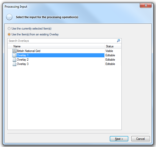
You have the following options:
Use the currently selected Item(s)
If you have Item(s) selected in the Map Window this option will be selected by default but can be changed to the following option.
Use the Item(s) from an existing Overlay
If no Item(s) are selected this option will be selected and cannot be changed. In this case choose the required overlay.
Click Next.
The Processing Operations dialog will be displayed:

Select the required process.
When a process operation is selected the grey button:
will change to an active Save button:
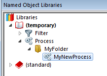
When you have defined your new process and entered all the required property values click the Save button to display the Save Process As dialog:
Enter a Folder name and Name for the Process and click OK.
The new Process will now be added to the current NOL:
Click Next in the Processing Operations dialog.
Before the process can start the output type must be specified. The Processing Output dialog will be displayed to allow you to do this:

This dialog allows you to specify the ouput for the selected process, as follows:
Create a new Overlay for the processed Item(s)
If you select this option the Create Overlay... button will become active. Click this button to display the New Overlay Types dialog:
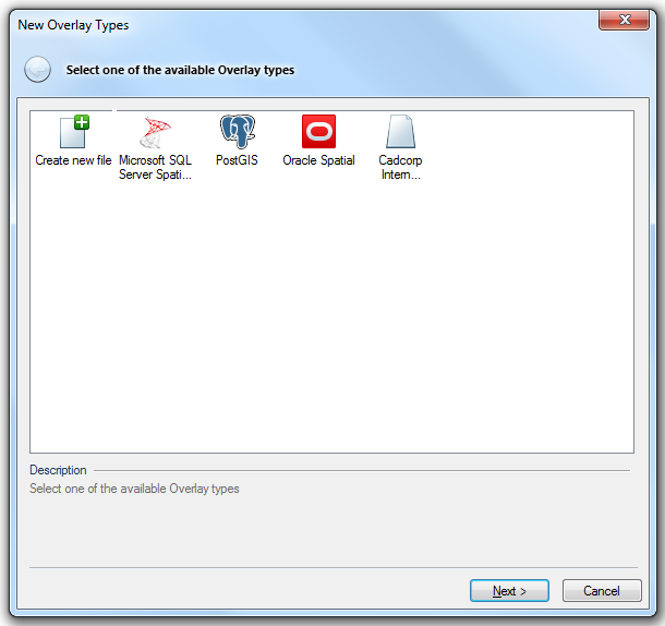
Create new file
Saves the file in any of the following formats:
Cadcorp Base Dataset (*.bds)
Cadcorp Feature Database (*.fdb)
Cadcorp Item Database (*.idb)
Microsoft SQL Server Spatial Dataset
This is an editable dataset that stores items in a Microsoft SQL Server Spatial database, using the planar geometry type.
See Microsoft SQL Server Spatial Dataset for the full description of the Microsoft SQL Server Spatial Dataset option.
PostGIS
This is an editable dataset that stores items in a PostGIS-enabled PostgreSQL database, using the PostGIS spatial schema.
See PostGIS for the full description of the PostGIS option.
Oracle Spatial
This is an editable dataset that stores items in an Oracle 9i, or later, Spatial database, using the Oracle Object-Relational schema.
See Oracle Spatial for the full description of the Oracle Spatial option.
Cadcorp Internal Dataset
This is an internal dataset. Contents of the internal dataset are stored within the SWD file and cannot be shared with other SWDs.
The Internal Dataset dialog will be displayed to allow the name for the new overlay to be entered.
Replace the input Item(s) with the processed Item(s)
The input Item(s) will be replaced with the processed Item(s). Only use this option if you do not need to keep the input Item(s).
Add the processed Item(s) to an existing Overlay
The processed Item(s) will be added to an existing overlay, keeping the input Item(s).
When the selection has been made click Finish.
The process will now be carried out.
The processing operations are categorised as shown below. Click on the category title, or the individual process, to go to the page containing the process descriptions.
Note: Properties marked with an * in the process descriptions are mandatory.
| Copy | Copies an existing Item |
| Decompose | Breaks down Items with complex geometry into separate Items |
| Filter | Filter Items using an expression |
| Group by | Group Items using an expression |
| Sort | Sort Items by a value |
| Create box | Creates a rectangular Polygon, around a centre point |
| Create ellipse | Creates an elliptical Polygon |
| Create line (bearing/distance) | Creates a LineString from a bearing and distance |
| Create point | Creates a Point Item |
| Create points in Polygon | Creates random points inside a Polygon |
| Create points on LineString | Creates random points along a LineString |
| Create sector (bearing/angle) | Creates a sector Polygon from a bearing and angle. |
| Create sector (start/end) | Creates a sector Polygon from a start and end angle |
| Join points | Joins the origin points of Items together into a LineString Item |
| Join points (advanced) | Joins the origin points of Items together into one or more LineString Items |
| Boundary | Gets the boundary of an Item. |
| Clip inside | Clips parts of source Items that are inside a clipping Item from another Overlay |
| Clip outside | Clips parts of source Items that are outside a clipping Item from another Overlay |
| Close | Closes any open geometry, joining the end to the start |
| Convex hull | Creates a convex hull Polygon around an Item |
| Envelope | Creates an envelope Polygon around the extents of an Item |
| Explode parts | Explodes each 'part', of an Item into a separate LineString |
| Explode segments | Explodes each 'segment' |
| Explode vertices | Explodes each vertex of an Item into a separate Point |
| Facet | Facets curved geometry segments into a straight geometry |
| Fill | Fills the boundary of an Item |
| Join LineStrings | Joins LineString Items together to make a longer LineString Item, within a tolerance |
| Move | Moves an Item in X and/or Y and/or Z |
| Remove interior loops | Removes interior loops (holes and islands) from Polygons, leaving only exterior loops |
| Reverse geometry | Reverses the geometry of an Item |
| Rotate | Rotates the geometry of an Item about a hook point |
| Scale | Scales the geometry of an Item about a hook point |
| Smooth (mid-points) | Smoothes the geometry of an Item, keeping segment mid-points fixed |
| Smooth (vertices) | Smoothes the geometry of an Item, keeping vertices fixed |
| Strip geometry | Strips the geometry of an Item, leaving an Empty Item |
| Generalise (Douglas-Peucker N) |
Generalises geometry using a variation of the Douglas-Peucker algorithm that is limited by the number of output points |
| Generalise (Douglas-Peucker) |
Generalises geometry using the Douglas-Peucker algorithm |
| Generalise (Perpendicular Distance) |
Generalises geometry using the Perpendicular Distance algorithm |
| Generalise (Radial Distance) |
Generalises geometry using the Radial Distance algorithm |
| Generalise (Reumann-Witkam) |
Generalises geometry using the Reumann-Witkam algorithm |
| Remove duplicates (by expression) |
Removes duplicate items based on an expression |
| Remove duplicates (by geometry) |
Removes duplicate items based on their geometry |
| Remove self-intersections | Removes self-intersections, e.g. a bow-tie |
| Remove short segments | Removes segments shorter than a tolerance |
| Remove spikes | Removes vertices that cause a spike |
| Remove straight segments | Removes vertices between straight, or near straight segments. |
| Simplify | Simplifies the geometry of an item, so that it matches the OGC 'simple' form |
| Remove all attributes | Removes all attributes from an Item |
| Remove attribute | Removes an attribute from an Item |
| Set property | Sets a property on an Item |
| Set styles | Sets styling information on an Item |
| Strip styles | Strips all styling information from an Item. Returns Brush, Pen and Symbol Items to "By Overlay" |
| Buffer | Creates a buffer around an Item |
| Cluster | Clusters Items together within regular, rectangular grid cells |
| Create Thiessen Polygons | Creates Thiessen Polygons of influence around the hook point of Items |
| Dissolve | Merges Items based on attribute values. |
| Geodetic buffer | Creates a 'geodetic' buffer around an Item |
| Intersect | Combines the Items using the intersect boolean operation |
| QZone buffer | Creates a QZone buffer around an Item |
| Subtract | Combines the Items using the subtract boolean operation |
| Symmetric difference | Combines the Items using the symmetric difference boolean operation |
| Union | Combines the Items using the union operation |
| Viewshed (as Grids) | Creates 'Viewshed' Grids from the Item origin over source Grid Items from another Overlay |
| Viewshed (as QZone) | Creates a'Viewshed' QZone from the Item origin over source Grid Items from another Overlay |
| Viewshed (as binary Grids) | Creates 'Viewshed' Grids from the Item origin over source Grid Items from another Overlay, containing only the cell values 1 (in Viewshed) and 0 (not in Viewshed) |
| Compress | Compresses a bitmap |
| Convert to grayscale | Converts a colour bitmap to a grayscale bitmap |
| Convert to sepia | Converts a colour bitmap to a sepia bitmap |
| Crop | Crops a bitmap |
| Create Terrain Ruggedness Index | Creates a Terrain Ruggedness Index map |
| Create Topographic Position Index | Creates a Topographic Position Index map |
| Create aspect | Creates an Aspect map |
| Create contours (fixed intervals) | Creates contour LineString Items from a Grid, at fixed intervals |
| Create contours (fixed levels) | Creates contour LineString Items from a Grid, at fixed levels. |
| Create hillshade | Creates a shaded relief map from a Grid |
| Create points | Explodes a Grid Item into one Point Item per Grid cell |
| Create polygon coverage | Creates a coverage of Polygon Items from a Grid. |
| Create polygons | Explodes a Grid Item into one Polygon Item per Grid cell. |
| Create roughness | Creates a Roughness map |
| Create slope | Creates a Slope map |
| Set cell value | Sets the value of all Grid cells that match a comparison against the 'from' value to the 'to' value |
| MapQuest Open | Connects to the MapQuest Open Geocoding service |
| Microsoft Bing Maps | Connects to the Microsoft Bing Maps geocoding service |
| OS (GB) Code-Point Open | Searches OS (GB) Code-Point Open data, by postcode |
| OS (GB) National Grid Reference | Matches search strings against OS (GB) National Grid References |
| OS (GB) National Grid Reference (Jersey) | Matches search strings against OS (GB) National Grid References for Jersey |
| Remove all attributes | Removes all attributes from an Item |
| Strip styles | Strips all styling information from an Item |
Top of page
Send comments on this topic.
Click to return to www.cadcorp.com
© Copyright 2000-2017 Computer Aided Development Corporation Limited (Cadcorp).


