
The Home tab is divided into five logical command groups as shown below:
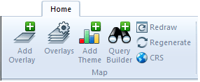
| Add Overlay | Adds a new overlay. |
| Overlays | Edits the overlays in the current window. |
| Add Theme | Adds a new theme to an existing overlay. |
| Query Builder | Uses the Query Builder to construct a data query to find items in an overlay. |
| Redraw | Redraws the graphics in the current window. |
| Regenerate | Makes sure all referenced datasets are as up-to-date as possible. |
| CRS | Sets up the coordinate system, viewing projection and units. |

| In | Zooms in by snapping or dragging. |
| Out | Zooms out by snapping or dragging. |
| Selection | Zoom selection. |
| Box | Zooms to the extents of a box in the aspect ratio of the current Map Window. |
| Gazetteer | Finds and zooms to a location. |

|
|
.gif) Zoom Drag Zoom Drag |
Dynamically zooms in and out of the window by dragging the mouse. |
.gif) Zoom Extents Zoom Extents |
Zooms to show all the graphics in the current window. |
.gif) Zoom All Zoom All |
Shows the theoretical limits of the current window. |
.gif) Zoom To Scale Zoom To Scale |
Zooms the current window to an approximate display scale. |
.gif) Zoom Raster Zoom Raster |
Zooms so that the screen pixels match raster item pixels. |
.gif) Roamer Roamer |
Creates a dynamic zoomed view of the window. |
.gif) Zoom Grid Reference Zoom Grid Reference |
Zooms to Grid Reference (e.g. OS National Grid in Great Britain). |

|
|
.gif) Back (Alt+Left) Back (Alt+Left) |
Goes to the previous view. |
.gif) Forward (Alt+Right) Forward (Alt+Right) |
Goes to the next view. |
.gif) Home (Alt+Home) Home (Alt+Home) |
Goes to the original view. |

|
|
.gif) Set Keyhole Overlay Set Keyhole Overlay |
Sets the keyhole overlay. |
.gif) Keyhole (F11) Keyhole (F11) |
Creates a dynamic keyhole view of the window. |
.gif) Rocket Rocket |
Automatically zooms out, then back in to the original view. |
.gif) Bungee Bungee |
Automatically zooms in, then back out to the original view. |

| Drag | Drags the current view using the mouse. |
| Snap | Changes the centre of the view. |
| Slide | Pans continuously over the map. |
| Recentre | Recentres the current view from a single snap in any view. |
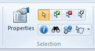
| Properties | Edits the properties of the currently selected item(s) |
 (Group) (100).gif)
|
|
 button (100).gif) Select Select |
Selects items, so they can be operated on by subsequent commands. |
.gif) Select All Select All |
Selects all items in the current document. |
.gif) Deselect All Deselect All |
Deselects all selected items. |
.gif) Toggle Selection Toggle Selection |
Reverses the current selection state. |

|
|
.gif) Get Info Get Info |
Click on an item to show its information. |
.gif) Find Find |
Finds and selects items. |
.gif) Get Feature Info Get Feature Info |
Click on an OGC WMS Image Item to get feature information from the server. |
.gif)
|
|
| Polygon Fence | Selects the items that are inside a polygon. |
| Circle Fence | Selects the items that are inside a circle. |
| Buffer Fence | Selects items close to a line. |
| Offset Fence | Selects items that are near existing geometry. |


|
|
.GIF) Measure Position Measure Position |
Measures a position relative to current axes. |
.gif) Measure Distance Measure Distance |
Measures the distance between two points. |
.gif) Measure Area Measure Area |
Measures the area of a 'fence' polygon. |
.GIF) Measure Angle Measure Angle |
Measures the angle between two lines. |

|
|
.gif) Measure Geometry Length Measure Geometry Length |
Adds up the lengths of the selected items. |
.gif) Measure Geometry Area Measure Geometry Area |
Adds up the areas of the selected items. |
.gif) Measure Geometry Volume Measure Geometry Volume |
Measures the total volume of the selected items. |
.gif) Measure Geometry Radius Measure Geometry Radius |
Measures the radius of a curved line. |
Send comments on this topic.
Click to return to www.cadcorp.com
© Copyright 2000-2017 Computer Aided Development Corporation Limited (Cadcorp).