 Geospatial Data Abstraction Library (GDAL) Geospatial Data Abstraction Library (GDAL)
Location: Overlay Types dialog > Miscellaneous > Geospatial Data Abstraction Library (GDAL)
Loads data via the Geospatial Data Abstraction Library (GDAL).
The Geospatial Data Abstraction Library (GDAL) is a library for reading and writing raster geospatial data formats, it is released under license by the Open Source Geospatial Foundation. (http://www.osgeo.org/).
GDAL is used by SIS for the majority of raster geospatial data formats. If a file does not load using a standard SIS interface, it is worth trying to load the file using this GDAL interface. See http://www.gdal.org/ for details of GDAL.
SIS uses GDAL to provide a single data abstract model for reading and exporting the majority of raster formats supported. More information can be found at http://www.gdal.org/formats_list.html
SIS supports GDAL datasets with multiple bands of depth.
The Geospatial Data Abstraction Library dialog will be displayed to allow you to browse for the file name, URI, etc.
Example:

Browse to the required file and click OK.

See the following Example of loading a netCDF dataset in grid format which includes details of the use of the Configure button.
Take as an example the file Conf1_maxabstemp.nc which has two subdatasets named bathymetry and maxtemp.
Display the Overlay Types dialog, select the Miscellaneous tab, select Geospatial Data Abstraction Library (GDAL) and click Finish.

In the Geospatial Data Abstraction Library dialog enter the dataset name.
If there are no subdatasets, just enter the filepath. In this case the dataset is a conventional dataset and the Configure button will be enabled. Otherwise, it will be disabled and this behaviour signals that the dataset is a container of subdatasets.
If there are subdatasets you need a prefix (NETCDF) and a suffix (the subdataset name) to address them as follows:
NETCDF:"filename.nc":subdatasetname
Example:
NETCDF:"D:\Data\Conf1_maxabstemp.nc":bathymetry
or
NETCDF:"D:\Data\Conf1_maxabstemp.nc":maxtemp
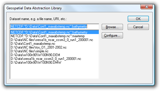
You can press Browse... to locate the filename, however, the additional parameters (NETCDF and the subdataset name) must be typed into the Geospatial Data Abstraction Library dialog top box.
Press Configure... to display the Band Configuration/Colour Model dialog:
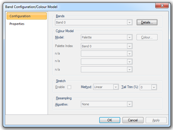
Select Grid from the Model: drop-down list and click OK.
Click OK on the Geospatial Data Abstraction Library dialog.
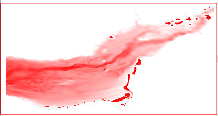
The grid format dataset will now be displayed:
The Properties of Grid dialog, displayed from the Map Window local menu, will confirm the grid image with the Class name:Grid

| GDAL Code | Description |
| AAIGrid | ArcInfo ASCII Grid |
| ADRG | Compressed ARC Digitized Raster Graphics |
| AIG | Arc/Info Binary Grid (.adf) |
| BSB | NOAA/MAPTECH/NDI/Softchart BSB |
| BT | Binary Terrain Format |
| DIMAP | SPOT Digital Image Map |
| DOQ1 | USGS Digital Orthophoto Quadrangles (old) |
| DOQ2 | USGS Digital Orthophoto Quadrangles (new) |
| DTED | Digital Terrain Elevation Data (.dt0, .dt1, .dt2) |
| ENVI | ENVI .hdr Labelled Raster |
| EHdr | ESRI .hdr Labelled (Supports BIL/BIP/BSQ based datasets) |
| ERS | ER Mapper |
| ESAT | Envisat Image Product (.n1) |
| FAST | EOSAT FAST Format |
| GIF | Graphics Interchange Format (.gif) |
| GMT | GMT Compatible netCDF grid format (*.grd) (only on x32 not in x64) |
| GS7BG | Golden Software Surfer 7 Binary Grid |
| GSAG | Golden Software ASCII Grid |
| GSBG | Golden Software Binary Grid |
| GTiff | GeoTiff |
| GXF | GXF - Grid eXchange File |
| HDF4 | Hierarchical Data Format Release 4 (HDF4) (only on x32 not in x64) |
| HDF4Image | (only on x32 not in x64) |
| HDF5 | Hierarchical Data Format Release 5 (HDF5) (only on x32 not in x64) |
| HDF5Image | (only on x32 not in x64) |
| HFA | ERDAS Imagine |
| INGR | Intergraph Raster |
| ILWIS | ILWIS Raster Map (.mpr,.mpl) |
| JAXAPALSAR | JAXA PALSAR Product Reader (Level 1.1/1.5) |
| JDEM | Japanese DEM (.mem) |
| JP2KAK | JPEG2000 (.jp2, .j2k) |
| JPEG | JPEG JFIF (.jpg) |
| L1B | NOAA Polar Orbiter Level 1b Data Set (AVHRR) |
| MEM | In Memory Raster (In-memory: has an auxiliary role in warping operations.) |
| MFF | Vexcel MFF |
| netCDF | NetCDF (only on x32 not in x64) |
| NITF | NITF |
| NWT_GRD | Northwood/VerticalMapper Numeric Grid Format .grd/.tab |
| PAux | PCI .aux Labelled |
| PCIDSK | PCI Geomatics Database File |
| PNG | Portable Network Graphics (.png) |
| Rasterlite | Rasterlite - Rasters in SQLite DB |
| RPFTOC | Raster Product Format/RPF (CADRG, CIB) |
| SAR_CEOS | SAR CEOS |
| SDTS | USGS SDTS DEM (*CATD.DDF) |
| SRTMHGT | SRTM HGT Format |
| USGSDEM | USGS ASCII DEM / CDED (.dem) |
| VRT | GDAL Virtual (.vrt) |
Send comments on this topic.
Click to return to www.cadcorp.com
© Copyright 2000-2017 Computer Aided Development Corporation Limited (Cadcorp).